Our travel startup client gained a powerful geolocated social network app. We developed a mobile app that helps tourists find nearby events and attractions, connect with other travellers, and access valuable information about their surroundings. This fosters a more engaging travel experience and strengthens connections between tourists and businesses.
The start-up was founded in 2017 in the United States. Its team comprises experienced professionals in technology, tourism and hospitality. The company aims to create a new generation of mobile applications for tourists and businesses.
Prior to the collaboration, our client aimed to create a platform that could seamlessly provide tourists with real-time information about nearby places and events, facilitate communication with other travellers and offer useful information about their surroundings. This required integrating multiple features such as geolocation, instant messaging and augmented reality into a single platform. The client saw untapped potential in these technologies to improve the travelling experience and needed a trusted partner to bring this idea to life.
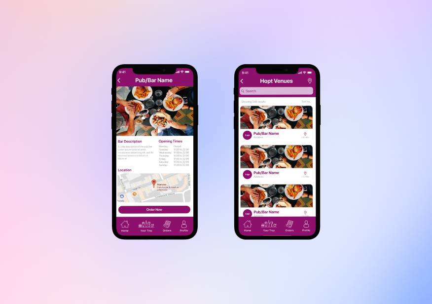
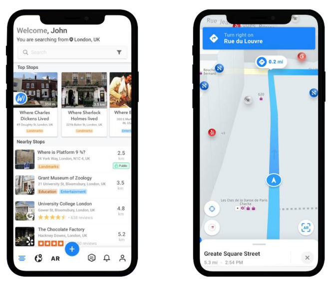
Computools developed a comprehensive geolocated social network application to address the client’s needs. Our team designed and implemented a platform that includes features such as geospatial search, instant messaging, and augmented reality. The application enables users to discover nearby attractions and events, share images, send messages, and collaborate within the app. It also provides 3-D navigation.
Computools’ experience and the expertise of our engineers allow us to create, implement, and ensure the stable operation of applications with a wide range of features. This project resulted in an application distributed among local and international users. Due to its usefulness for a wide audience, including various industries and businesses, the client’s profit has increased several times.
SMARTCITY’s decision to partner with Computools was driven by a combination of factors. Computools’ demonstrated expertise in the travel and tourism industry and our proven track record of successfully delivering innovative mobile app solutions instilled confidence in SMARTCITY’s leadership. Furthermore, Computools’ agile development methodology, characterised by transparency and open communication, aligned perfectly with SMARTCITY’s collaborative approach.
The client sought to create a product that would be equally useful to businesses and customers, able to connect them and enhance their journey with useful information. The main principle is to display useful information about nearby establishments in the app and use augmented reality based on geodata.
SMARTCITY discovered Computools through industry recommendations and a thorough market search. They considered other development firms but chose Computools due to our expertise in platform and product engineering, particularly in the travel and tourism sector. Key product features like geospatial search, augmented reality integration, and a robust social media component made our solution stand out from competitors.
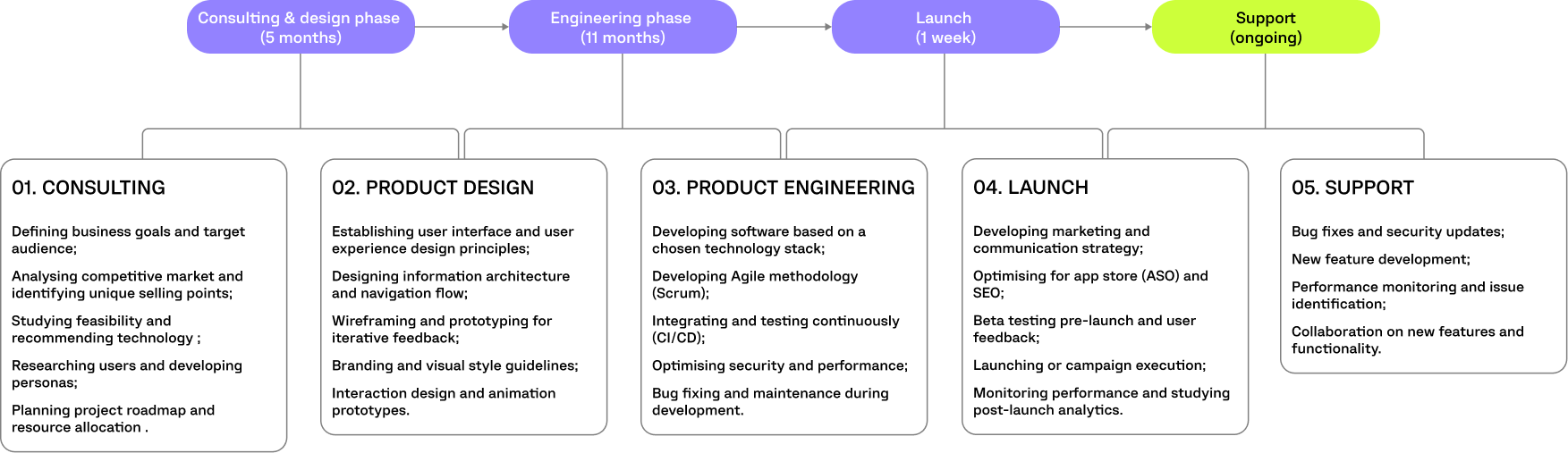
We focused on developing the core architecture, integrating advanced geolocation and AR features, and ensuring the app’s stability and performance. Our team provided end-to-end solutions from initial concept design to final implementation.
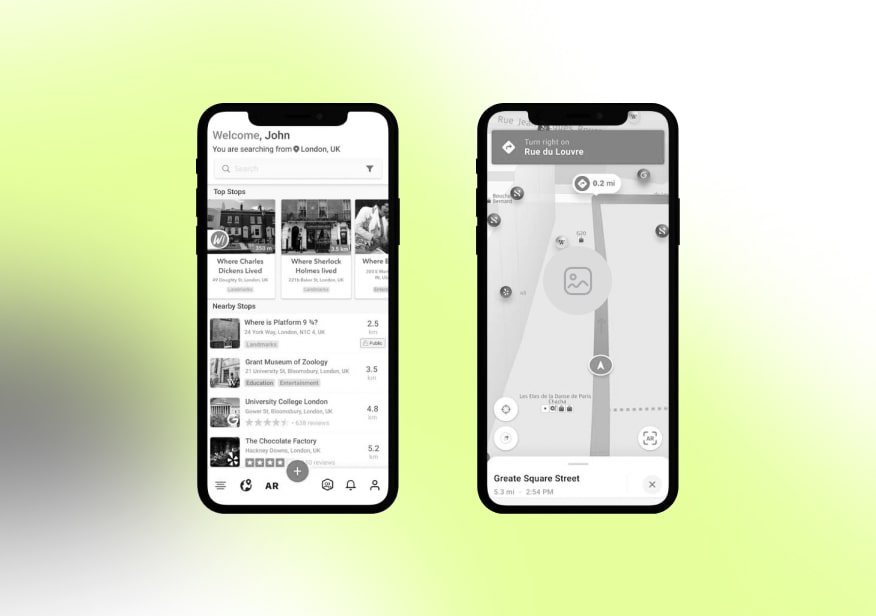
The app shows Wikipedia articles about the nearest objects, Google Place, general geo content, and more. The application is also supplemented with an internal instant messenger that allows the creation of groups and the sharing of information in a new way. Chat rooms can be private, public, or even just a place where users can collaborate with themselves until they’re ready to invite others.
The app also allows the user to tag any object in any photo, link it back to its original place and discover it in augmented reality when the user is there. The app gallery gives info about the weather at the time of the photo, the current weather and the closest Wikipedia articles to the location of your photo.
The designer’s role was to provide an intuitive interface and extreme responsiveness that would provide superior UX and high user retention.
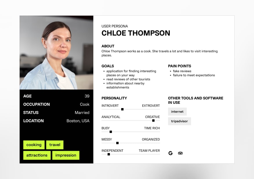
Unveiling the ideal tourist powering the platform
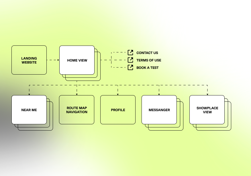
Structuring the website's layout and navigation.
Building the framework for a seamless user experience
Crafting the visual language of connection and discovery

Java
Java was designed to be easy to use and is, therefore, easier to write, compile, debug and learn than other programming languages. This allows the creation of modular programs and reusable code. One of the most significant advantages of Java is its ability to move easily from one computer system to another.

Android SDK
Android SDK is an open-source platform that allows developers to share worthy and precious technologies on a larger scale. It is coupled with many sets of libraries and development tools that help software programmers build and test various applications. Android SDK supports all Android versions, which means developers can also develop and test Android applications for older devices.

Retrofit 2
Retrofit is a REST Client for Java and Android. It makes retrieving and uploading JSON (or other structured data) relatively easy via REST-based web services. Retrofit is used in the following three classes: model class, which is a JSON model; interfaces that define the possible HTTP operations; Retrofit.Builder class - Instance, which uses the interface and the Builder API to allow defining the URL endpoint for the HTTP operations.

RxJava
Reactive extensions in Java allow you to manipulate multiple actions simultaneously due to certain system events. Rx allows you to use functional transformations over streams of events, and it doesn't require using nasty things like callbacks and global state management.

ButterKnife
ButterKnife is small, simple and lightweight. It allows developers to inject arbitrary objects, views and OnClickListeners so they can focus on writing useful code. Consider Android ButterKnife a reduction library.
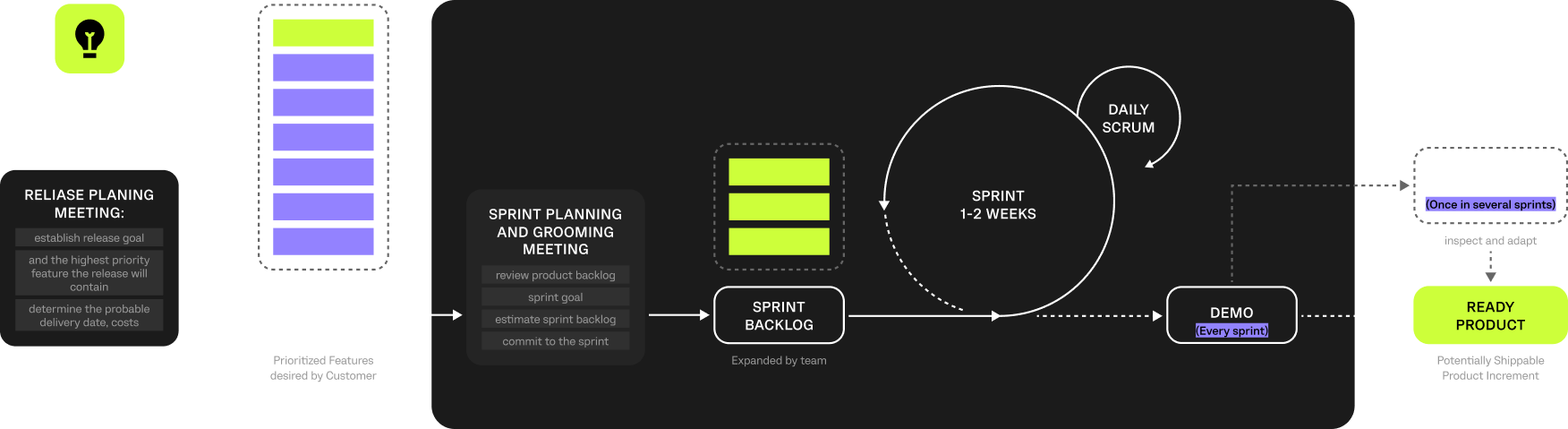
The optimal methodology is selected to work on the project, which determines how the code will be developed, tested and released. We chose Scrum, a flexible, agile methodology.
Scrum addresses complexity in work by making information transparent so that people can inspect and adapt based on current conditions rather than predicted conditions. Transparency of common terms and standards is required in Scrum development to ensure that what is being delivered is what was expected. A frequent inspection ensures progress and detects variances early on so that adjustments can be made quickly.
As a leader of the internal team for the travel startup, I can tell you firsthand how impactful Computools’ involvement was in the SMARTCITY project. Their team wasn’t just technically skilled but also understood the user experience we were trying to create.
During brainstorming sessions, they brought a fresh perspective, challenging our assumptions and pushing us to think outside the box. This collaborative approach led to some of the app’s most innovative features, like integrating real-time information with augmented reality.
Thanks to their expertise and organisation, the entire development process felt smooth and efficient.

Computools | 341 Raven Cir, Camden Wyoming, Delaware 19934, US